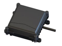
MICROBRAIN-TERRAIN RADAR H31-1
The MICROBRAIN H31-1 is an advanced 77GHz terrain following and altitude radar sensor for drones. It delivers precise 2cm accuracy for maintaining constant height above challenging terrain, crucial for agricultural spraying, mapping, and industrial inspections. Its all-weather performance ensures reliability in diverse outdoor environments, enhancing drone efficiency and safety.
Features :
Advanced 77-81GHz millimeter-wave radar.
2cm high-precision height measurement.
Enables precise terrain following.
Adapts to Pixhawk/Ardupilot FCs.
UART communication interface.
IP67 waterproof and dustproof.
Wide operating temperature range.
Compact size, lightweight (87g).
Detects distance to plants and ground.
Enhances agricultural spraying uniformity.
Technical Specifications:
- ModelUAV-H31-1
- Frequency77~81GHz
- Working Voltage5~24V DC
- Power Consumption≤3W
- IP LevelIP67
- Dimension76*71.5*19.6mm
- Data InterfaceUART
- Detection Range0.2~30m
- Ranging Accuracy±0.02m
- Ranging Resolution0.12m
- ApplicationAgricultural drone
- Beam Azimuth Width (-6dB)±15°
- Beam Elevation Width (-6dB)±4°
Additional Details:
Manufacturer: Microbrain Intelligent Technology Co., Ltd.
Brand: MICROBRAIN
Generic Name: Terrain Following Radar || Altitude Radar Sensor || Drone Altimeter || 77GHz Radar || UAV Height Sensor || Ground Tracking Radar || Agricultural Drone Sensor || Millimeter-Wave Altimeter || Smart Farming Sensor || Precision Altitude Sensor
Sold By: UAV Marketplace (an authorized seller of drone gear and accessories)
Ideal For: Agricultural Spraying Drones || Plant Protection UAVs || Precision Farming || Autonomous Terrain Following || Drone Mapping & Surveying (low altitude) || Industrial Inspection Drones (over uneven terrain) || Forestry Drones || Small Express Transport UAVs || Pixhawk/Ardupilot Flight Controllers || Custom Drone Builds
Package Details:
Includes:
1x MICROBRAIN H31-1 Terrain Radar Sensor
Frequently Asked Questions:
Q1. What makes the MICROBRAIN H31-1 radar ideal for agricultural spraying drones?
Ans. The MICROBRAIN H31-1 radar is ideal for agricultural spraying drones due to its highly accurate 2cm height measurement and 77GHz frequency band, enabling precise terrain following. This ensures the drone maintains a consistent spray height above crops, regardless of ground undulations, leading to uniform application of pesticides or fertilizers. Its IP67 rating also guarantees reliable performance in dusty and wet agricultural environments.
Q2. How does the 77GHz frequency of the H31-1 compare to 24GHz radars often found on drones?
Ans. The 77GHz frequency of the MICROBRAIN H31-1 radar offers several advantages over common 24GHz drone radars. Generally, higher frequencies allow for smaller antenna sizes, higher measurement accuracy (2cm for H31-1), and better resolution for distinguishing between closely spaced objects or ground features. While 24GHz is robust, 77GHz can provide more precise data crucial for demanding applications like accurate terrain following over crops or complex landscapes.
Q3. Is the MICROBRAIN H31-1 Terrain Radar compatible with open-source flight controllers like Pixhawk or Ardupilot?
Ans. Yes, the MICROBRAIN H31-1 Terrain Radar is designed to be compatible with popular open-source flight controllers such as Pixhawk and Ardupilot. It uses a UART (serial port) communication interface, which is widely supported by these flight controllers. Users typically need to connect the sensor's UART pins to an available serial port on the flight controller and configure the appropriate parameters in the flight controller's firmware to enable terrain following functionality.


