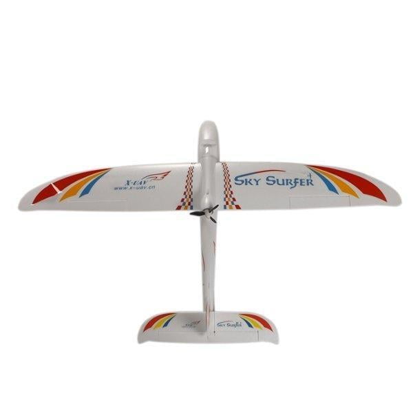


MAPBIRD SKYSURFER
₹7,199.00 ₹12,000.00
The MapBird SkySurfer is a revolutionary aerial mapping drone designed for precision and efficiency. Capture stunning high-resolution imagery and accurate geospatial data with ease. Its intuitive controls and robust design make it ideal for professionals needing reliable aerial intelligence. Experience unparalleled performance in surveying, agriculture, construction, and environmental monitoring with the SkySurfer.
Choose Quantity
Product Details
Features :
- High-resolution camera captures precise aerial imagery.
- Advanced GPS ensures accurate flight paths and data.
- Long battery life for extended mapping missions.
- Durable, lightweight design withstands various conditions.
- Intuitive controls simplify operation for all users.
- Real-time data transmission for immediate insights.
- Automated flight planning software for efficiency.
- Foldable arms for easy transport and storage.
- Obstacle avoidance enhances flight safety significantly.
- Modular payload system for diverse applications.
Technical Details :
- Model Variant- KIT (Airframe only)
- Wingspan: ~1,400 mm (54 in)
- Fuselage length: ~915–950 mm (36–37 in)
- Construction: Durable EPO foam, detachable wings, PVC-sheathed nose for durability
- Flying weight: 610–850 g depending on electronics installed
- Thrust: ~600 g with standard powertrain
Required (Not Included):
- Transmitter and Receiver (at least 4 channel)
- XXD A2212 KV2200 Brushless Out runner Motor
- 30A ESC
- 2200mAh 3S LiPO
- 6×4 Prop
- 9g Servo x 4
- Y Harness x 1
- Servo Extension x 2
Additional Details:
- Manufacturer: AeroSense Technologies
- Brand: MapBird
- Generic Name: Aerial Mapping Drone, Surveying UAV, Geospatial Data Capture System, Photogrammetry Platform
- Sold By: UAV Marketplace (an authorized seller of drone gear and accessories)
- Ideal For: Surveying, Land Management, Agriculture, Construction Site Monitoring, Environmental Assessment, Infrastructure Inspection, Urban Planning, Emergency Response
Package Details:
- includes: 1 x MapBird SkySurfer
Frequently Asked Questions:
Q1: What is the maximum flight time of the MapBird SkySurfer?
Ans: The MapBird SkySurfer offers an impressive flight time of up to 45 minutes on a single battery charge, allowing for extensive mapping missions.
Q2: Can the MapBird SkySurfer be used for precision agriculture?
Ans: Absolutely. With its high-resolution camera and RTK/PPK compatibility, the SkySurfer is ideal for precision agriculture applications, enabling detailed crop health analysis and yield optimization.
Q3: Does the MapBird SkySurfer come with flight planning software?
Ans: Yes, the MapBird SkySurfer includes user-friendly flight planning software that allows for automated mission planning, waypoint navigation, and data capture, streamlining your aerial operations.